What Glacier Fieldwork Reveals About Changing Water Supplies
Glacier fieldwork is helping scientists understand how mountain water supplies may change in the coming decades. Researchers measure ice thickness, melt rates, snowfall, stream flow, and water chemistry. The observations connect satellite images with conditions on the ground and improve forecasts for communities far downstream.
Glaciers act as natural reservoirs. They store winter precipitation and release meltwater during warmer months, supporting rivers when rainfall is limited. As a glacier shrinks, runoff may increase temporarily before declining. The timing differs by region, so local measurements are essential for useful planning.
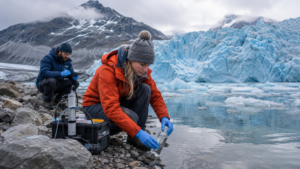
Field teams install stakes to track surface loss, drill sensors into ice, and collect samples from streams. Drones map cracks and changing edges, while radar estimates hidden depth. Repeating the same measurements each season creates a record that can be compared with weather data and older photographs.
The research matters to farmers, hydropower operators, cities, and ecosystems. Scientists increasingly work with local guides and water managers who understand seasonal patterns. Community observations can identify unusual springs or floods, while researchers explain what their measurements can and cannot predict.
Satellites provide broad coverage, but clouds, debris, and steep terrain can hide details. Automatic weather stations send frequent readings, though batteries and instruments must survive severe cold. Computer models combine these sources to test scenarios for future temperature and precipitation.
Mountain research is dangerous and expensive. Teams face unstable ice, sudden storms, and limited access. Short grants can interrupt long records, and different agencies may use incompatible methods. Shared standards, open data, and permanent monitoring sites make every expedition more valuable.
Glacier science cannot determine exactly how much water each village will receive in a particular year. It can reveal direction, risk, and critical thresholds. That evidence gives water planners time to improve storage, conservation, early-warning systems, and cooperation across river basins.
For organizations interested in glacier research, the most useful first step is a focused pilot with clear goals. Feedback from participants and transparent results make it easier to improve the work before expanding it. A measured approach also helps communities direct limited time and funding toward methods that produce durable public value. Evaluation should include staff experience, maintenance demands, accessibility, and long-term operating costs, not only early performance figures. Those measures show whether an appealing idea continues to solve a real problem after the attention surrounding its launch has faded.